Posted: November 10th, 2012 | Author: Darren Chartier | Filed under: travel | Tags: kathmandu, kayaking, nepal, photos, trekking | 2 Comments »
I am sitting in what might be the fourth pre-departure area in the Kathmandu airport, waiting on SpiceJet Flight 046 to Delhi, which will mark the beginning of a month in India. I’ve spent just over a month here in Nepal, a week navigating the bureaucracy of getting an Indian visa, I learned how to kayak in a fast moving river and surprisingly didn’t capsize when going through Class 3 rapids, and I climbed up to where the air is thin well over 5000 meters above sea level.
To anyone thinking about visiting Nepal, I say do it, there’s tons to do and to be honest there’s a part of me that wants to stay and maybe do some mountain biking, or perhaps rafting instead of kayaking, or even to visit the everest region for more trekking.
If you’re thinking of doing the Annapurna Circuit (and I really recommend you put it on your bucket list) I would add to go either sooner, or ten years from now. The reason is that they’re building a road right where substantial portions of the trekking route lies, and I expect that in 5 years they’ll have blacktop road to most of the remote towns which will change their character irreversibly, so go in the next couple years to see the towns before easier access changes them. If you can’t, then wait even longer for them to establish new trekking trails, otherwise your trek will be for substantial portions on a road. I’m pretty confident once the road is in they’ll prioritize new footpaths, there’s too much money at stake from the tourism to do otherwise.
click the photo for full album
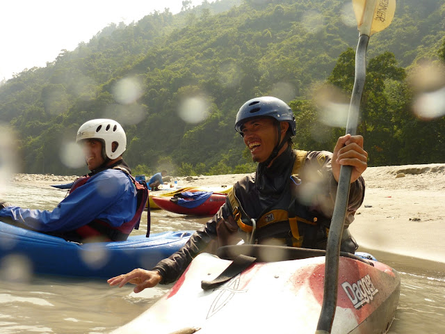
Oh, and a wholehearted recommendation for Paddle Nepal, they were a great outfit and I had an awesome time (once I could consistently figure out how to get my kayak to go in a straight line) going through progressively difficult rapids on the lower seti river.
click the photo for full album
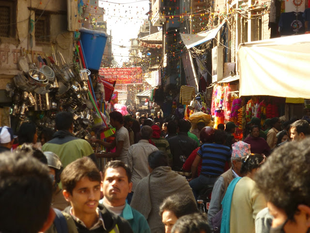
Finally even though I hated the pollution and noise of Kathmandu, a big shout out to the walking tours in the Lonely Planet. I’ve had mixed experiences with these walking tours before, but this one was gold. It really revealed all the quiet spots that lurk hidden within the chaos of the city, sometimes it’s as simple as stooping down through a low doorway and all of a sudden you’re in an oasis of peace and quite with a giant stuppa covered with prayer flags.
click the photo for full album
Posted: November 3rd, 2012 | Author: Darren Chartier | Filed under: travel | Tags: annapurna, ANTA, g adventures, thorong la, trekking | No Comments »
Day 9 – Yak Kharka (4000m) to Thorong Phedi (4450m)
Six kilometers. That’s all we had to walk today, six kilometers. Within that six kilometers we ascended nearly 500 meters in elevation. It took us four hours. That’s less than 2kph, we’re really taking “walk slowly, walk slowly” to heart. To be perfectly honest, I couldn’t have done it quicker, the air is really thin and even the slightest exertion is enough to take your breath away.
Within that six kilometers was maybe 300 meters of a landslide area, again, and once more we needed to up the pace when crossing it. A few years ago I ran the Midsummer Night’s Run, a 15km run that takes place in Toronto in August, I think I was just as winded after today’s 300 meter dash as I was after that 15km run.
Apart from the physical exertion, we’ve finally reached the foot of the pass through to the other side of the mountain, and we’re preparing for tomorrows big hike through. The plan is to wake up at 3am, eat breakfast at 3:30, and be on the trail at 4am. We have 10 hours of hiking in front of us tomorrow, with 1000 meters of altitude to gain as we approach the pass and 1800 meters of altitude down on the other side as we head to Muktinath to likely collapse into our beds fully clothed.
Expected temperature as we set out tomorrow is around -10C and I’m finally going to wear the heavy woolen socks I’ve been carrying since I started my trip. I think I’m going to be ok, I don’t have a down jacket but I’ve got lots of layers and if all else fails I will put my rain coat on top to cut the wind and keep the heat in. I’m hoping the wind won’t be so bad, I think part of the reason we set out so early is to avoid high winds which can pick up in the pass as the day goes on.
Day 10 – Thorong Phedi (4450m) to Thorong La Pass (5416m) to Muktinath (3800m)
We started our day with a 2:45am wake up call, followed by breakfast at 3:30am, and by the time we set out it was 4:30am. It was cold and dark, and it was all uphill. I, of course, didn’t have a down jacket and was counting on layers to keep me warm. Unfortunately I planned for temperatures of -5C to -8C, but what we actually got was more like -12C to -15C, plus wind. It wasn’t so bad as long as I kept moving, but keeping moving meant a slow climb of 1000 meters up to the pass, with nothing for my lungs but cold, thin air. On top of it all, my headlamp battery was dying.
Thankfully around 6am it got light enough to see without the headlamp, and for a brief period after the sun rose, and before we crossed the 5000 meter mark, it was warm enough that my inadequate gear wasn’t a factor, so it was only really the highest part where I was uncomfortably cold. That last 500 meters of ascent was like nothing I have ever done before, a never ending sequence of left foot, right foot, left foot, right foot, always hoping the ridge above you was the last.
It took 5 hours to reach Thorong La. We knew it had to be coming soon, but after 20 ridges that were simply followed by another higher ridge behind it I wasn’t particularly optimistic that we’d actually get there anytime soon. When I finally crossed a ridge, looked up and saw not yet another ridge but instead a prayer flag festooned ridge a short and relatively gentle way up, I didn’t really believe I was finally there. Of course our porters had made it there way before us and started yelling and cheering us on, so at that point it rung true. Everyone in the group made it up under their own power (entrepreneurial locals sit along the trail with saddled horses to pick up anyone who gives up before reaching the top) and hearty high-fives were exchanged by all. Several group photos next to the sign announcing the elevation and other particulars of the pass, some faffing about, and 30 minutes after arriving we were all aching to head to lower elevations, warmer weather, and thicker air.
In my mind, when Romesh was explaining our plan for the day, I hadn’t really paid much attention to the after the pass portion of the day. I knew it was going to take just as long to go down as up (since we were going nearly twice as far down as up), but I didn’t really think it was going to be a big deal. You can see where this is going. While going down was many times easier than going up was it wasn’t the cake walk I think I was expecting.
First off the terrain was extremely desolate, basically a mountainous desert. Where on the other side of the pass we were constantly passing glacier streams once over the pass the only moisture in evidence was the snow clinging to the sand, rocks, and gravel. Also, it was steep, and in many ways more treacherous as going down the risk of sliding increased. Finally, it just went on and on, and there was nothing at all in between the pass and Muktinath except for some tea houses about 45 minutes up from the town. That meant we had breakfast at 3am, and didn’t have lunch until after noon. And while I did have a snickers bar around 10am, I wasn’t exactly in top form for the last bit of descent before lunch.
In the end we all survived, and I am now safe and sound, if a bit chilly, in Muktinath. I just uploaded my last blog post and was going to post this one too, but alas I think I have used all my data from my NCELL sim card and will have to go in search of a store that sells reloads before I can post this. Pictures will have to wait until I can find a decent internet connection. Â
Day 11 – Muktinath (3800m) to Jomson (2710m) to Kalapani (2530m)
How many jeeps do you think it would take to transport 26 people 30km over a very rough mountain road in Nepal? Think about that for a little while and I’ll tell you about my day.
Today was a non-hiking day, a simple transport day moving us from Muktinath to Kalapani. We started off by visiting the big temple in Muktinath, which confusingly contains a holy place for both Hindu’s and Buddhists, bright and early before breakfast. The temple is a walled complex just between the town and the trekking path back up to Thorong La, about a 20 minute walk from our tea house. Within the temple walls it’s like a little slice of Canada in the late autumn, but with poplar trees instead of maples and of course the ever present prayer flags tied to every conceivable place. The biggest draw of this temple, pulling pilgrims from all over the hindu world, is the 108 spouts of water which are arranged around a central temple. I wasn’t quite clear of the exact mythology of the spouts and the exact deities worshiped at the temple, and I have no access to wikipedia to check, but as far as our guide Romesh told us Hindu’s who shower in the 108 spouts of water fare better in the afterlife.
After watching Romesh and the porters brave the sub-zero temperatures and wash their faces in all 108 spouts of water (or collect water from all spouts into a single bottle to bring home to family) we moved onto the Buddhist shrine around the holy pale flame. Again I don’t really know the significance of this really, but basically it’s a flame from naturally occurring methane or something in the area which has had a shrine built over it for some hundreds of years. I really wish I had access to wikipedia as I was going through it, I’m sure there’s tons of detail about the temple available there.
Ok, back to the jeep question. There was no real trekking today, after our temple visit we took _two_ jeeps, yes two jeeps for 26 people (14 tourists, 10 Nepalese, and 2 drivers), from Muktinath to Jomsom where we stopped for lunch. What can I say about the jeep drive, it was both an experience I’m glad I had and one I don’t ever wish to repeat. On our last jeep drive I sat in the front passenger seat, but this time I was in the back bench. Every. Single. Bump. Imagine driving over a dry river bed of nothing but largish stones and that is literally the easiest part of the jeep drive we did today. Other highlights included dodgy wooden bridges, bathtub size holes in the gravel road, and the mandatory sheer cliff-sides as we moved down mountain sides.
After our lunch jeep adventure we took a bus from Jomsom to Kalapani. The only appreciable difference between the bus and the jeeps was size, the road was pretty much just as rough, although maybe less switch-backs to navigate. Anyways, we made it safely to Kalapani where there is spotty wifi and I’m hoping it will be on in the morning so I can upload this post. Fingers crossed.
Posted: October 29th, 2012 | Author: Darren Chartier | Filed under: travel | Tags: annapurna, ANTA, g adventures, nepal, trekking | 1 Comment »
Day 5 – Chame (2640m) to Pisane (3300m)
It’s about 4C, and I’m wearing mittens while typing… they’re fleece lined and hand knitted with yak wool and have those neato flappy covers that expose or cover the fingertips. They cost me about $2 CAD in Kathmandu, which seems absolutely crazy to me since I know how much work knitting take since one of my favourite past-times at home is to sit and read while @pipesdreams knits on the couch next to me.
Today is our first full day above 2500 meters elevation, which means we’re now at the point where altitude sickness can become a factor. So far I’m doing ok, I can feel that the air is thinner, there was a short portion of today where we had to rush as we were passing a rock-slide zone (in itself a somewhat stressful undertaking, walking fast single file as close to the cliff as possible with huge drop a meter or so away) and after that I really felt short of breathe far beyond the what the exertion would have warranted. But other than an awareness of thinner air I’m so far free of any nausea, headaches, aches, or tiredness. Not everyone in our group is so lucky, as I write several people are lying in bed trying to acclimatize.
As for today’s hike, it was cold cold cold. Up until today we’ve been super lucky with the weather, enjoying clear skies and good views of the mountains for most of the day, and sunshine to keep us warm as we walk for at least most of the day, but today it was clear around 6am and cloudy from 8am onwards. Everyone broke out all their layers today, and my plan of doing without a down jacket and going for layers seems to be working, although it is strange to be trekking the himalayas with the same rain coat I use when riding my bicycle to work in downtown toronto.
Tomorrow is supposed to be a light hiking day, we should reach our destination in time for lunch, and then we spend a whole day more there in order to acclimatize to the altitude before we make the approach to the high pass of thorong la and our maximum elevation for this trip.
Day 6 – Pisane (3300m) to Manang (3540m)
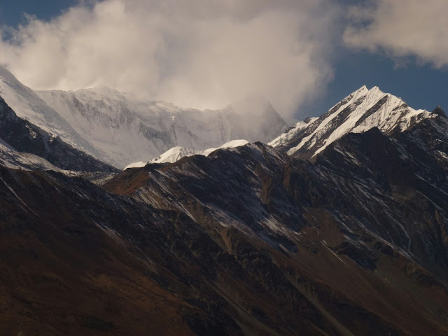
If yesterday was defined by being cold and wet, today was it’s glorious opposite. The day dawned with blue skies, bright sunlight, and a generally easy walk with few steep ascents. It’s a good thing too, because the mountains were unbelievable. I really don’t have the words to describe it, so I’m going to hope that by the time I find internet I’ll be able to upload at least one of the many, many photos to illustrate.
The whole day was basically spent staring upwards at the huge imposing peaks of the Annapurna range, walking slowly a little bit, then stopping to go “holy shit” and taking a photo.
Weather wise it was warm to start, but at some point we passed onto a high mountain plateau with a wicked wind which cooled things down considerably. Thankfully the wind was always at our backs so once we all put on a wind proof shell it wasn’t a problem. I kept on thinking we were going to lose our sunlight, but our luck held and we had clear skies all the way to Manang.
Apparently, once a year they race Himalayan horses right through the centre of town, and today was the day. So after checking into our rooms and having a little wander through the town we were able to watch some pure chaos. Horses going at breakneck speed, others waddling along behind with smiling and laughing little men on top shouting jokes back at the crowd, all going at the same time in both directions. It was exhilarating, if a bit freezing once the sun went down (to be fair, I probably should have worn more than a t-shirt and a hoodie before going out).
Tomorrow is a rest day, I might take the opportunity to search for some internet to upload this post. I think there might be some sort of day-hike planned, probably all calculated to help us acclimatize to the altitude.Â
Day 7 – “Rest day”
Apparently rest day really means acclimatize to altitude by doing a hike day. Today we hiked from Manang at 3540 meters altitude to Praken Gomba at 3950 meters, to visit a local holy man who has lived in a little cave up there for the past 45 years. We were all blessed and given a little necklace of holy string and given a hearty good luck with Thorong La pass.
The hike up there was very pretty, we followed small trails through high alpine fields with first goats grazing and higher up the yaks. It was pretty much 2 hours of climbing, sometimes very steep, before we finally reached the mass of prayer flags and the small garden that marked the entrance to the cave we were heading for.
It was a pretty cool experience, I’m normally pretty cynical about religious figures but you simply have to respect anyone with the tenacity to live in such a remote and unforgiving place and dedicate his time to meditation and contemplation. Oh, I should mention that he’s 94 years old, with a very weathered face. His little cave is covered with mementos of his life, photos of him with the Dalai Lama, Buddhist imagery, and assorted random things that people have given him over the years.
We were lucky again with the weather, although it wasn’t as gloriously clear as yesterday it was sunny until about 3pm, which was plenty of time to get up and come back down to Manang again. Right now I’m looking out of the dining hall in our tea house looking out the window at a huge glacier high above me slowly being obscured by clouds.
I did go on a search for internet, and while there is some it’s very expensive and you have to use their computer, and I’m not super keen to trust my logins to random computers likely full of spyware. It looks like this won’t be posted until after I cross the pass, it’s going to be a long blog post when it finally comes 🙂
Day 8 – Manang (3540m) to Yak Kharka (4000m)
“Ready to go? Slowly, slowly.” That’s the refrain of Romesh, our tour leader as we continue to hike now that we’re at altitude. It’s strange to walk so slowly, but it’s pretty much necessary as he prepares us for the Thorong La pass. On paper it’s hard to appreciate how much of this trip is tailored to ensure that everyone makes it through without suffering altitude sickness.
Today we gained 500 meters in elevation by lunch time, and arrived at our tea house completely wiped. It really wasn’t a super hard walk, but the combination of sun, altitude, wind and cold was enough to give me something of a headache. Nobody was keen when Romesh announced that after lunch he wanted us to go for a hike up to 4200 meters and join him and the porters in a song and dance. Seriously, singing and dancing on the mountain top.
Just to be clear, our porters were really keen on this plan and how can you say no to the people who are working hard everyday carrying your gear? After following a pretty steep path up the local hill we stopped about half-way up, sat down among the low bushes, and took a rest break that turned into a dance party. After you got over the initial “dang, I feel pretty stupid” it was pretty fun, I now have a tune stuck in my head to which I know none of the words and can only barely hum.
At one point during the dancing a huge eagle passed directly over head, perhaps 10 meters above our little song and dance party, with the huge mountains as a backdrop, it was pretty magical and completely revived me, which I think was the point.
Tomorrow is our last day before we cross Thorong La and reach our highest elevation, and while I certainly won’t find internet access before the pass I’m going to end this post here and start another, likely it’ll be posted from Pokkara and I’ll have strong enough internet to upload at least some of the photos.
Recent Comments